Hiking Trails at Oregon Caves
We have six hiking trails with wonderful views of Oregon Caves National Monument and the Siskiyou Mountains that surround it. Most of the trails weave in and out of the boundary of the Monument and Preserve.
Old Growth Trail
Distance: 1 mile (1.6 km) loop
Estimated Time: 30 to 45 minutes
Elevation Gain: 200 feet (60 m)
Trailhead: Visitor Center
This historic trail, connecting the Visitor Center to the main parking lot, gradually climbs past oak trees, over marble outcrops, and through old growth forests.
No Name Trail
Distance: 1.3 miles (2.1 km)
Estimated Time: 45 minutes to 1 hour
Elevation Gain: 268 feet (82m)
Trailhead: Chateau parking lot
Short but steep, you’ll encounter streams, mossy cliffs, and dense forests. Walk underneath the covered bridge along Cave Creek. Two short trails lead to two waterfalls on No Name Creek.
Cave Creek Trail
Distance: 3.6 miles (5.8 km) round trip
Estimated Time: 2 to 4 hours (round trip)
Elevation Gain: 1,245 feet (379 m)
Trailhead: Chateau parking lot
Wind your way down the mountain to the Cave Creek Campground. Enjoy the dense forest, splashing streams, and rock outcrops.
Note: For a 1 to 2 hour hike, consider arranging a ride to pick you up at the campground.
Cliff Nature Trail
Distance (from the cave exit): 0.7 mile (1.1 km)
Estimated Time: 30 minutes to 1 hour
Elevation Gain: 75 feet (23 m)
Trailhead: Cave exit
Distance (from Visitor Center): 1 mile (1.6 km)
Estimated Time: 45 minutes to 1 hour
Elevation Gain: 371 feet (113)
Trailhead: Visitor Center
Walk over marble outcrops, through the fir forests, and enjoy panoramic views of the Illinois Valley.
Big Tree Trail
Distance: 3.3 miles (5.3 km) loop, 1.3 miles (2.1 km) to Big Tree
Estimated Time: 3 hours (loop), 2.5 hours (Big Tree and back)
Elevation Gain: 1,125 feet (343 m)
Trailhead: Visitor Center
A great afternoon hike, a steep climb takes you through mountain meadows and forests, past the widest-girthed Douglas-fir tree known to exist in Oregon.
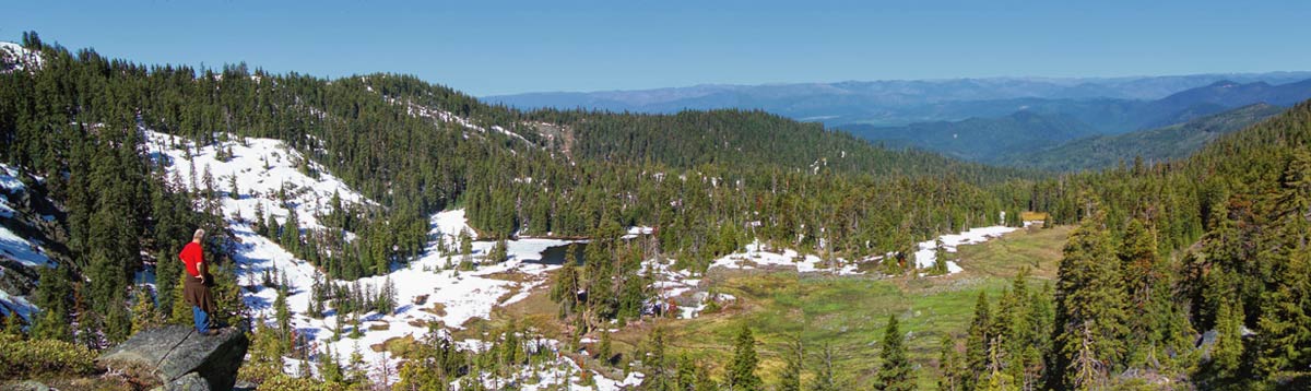
Bigelow Lakes – Mt. Elijah Loop Trail
Distance: 9.2 miles (14.8 km) loop; 8 miles (12.8 km) to Mt. Elijah and back
Estimated Time: 5 to 7 hours depending on route
Elevation Gain: 2,390 feet (728 m)
Trailhead: Visitor Center, follow Big Tree TrailThis full-day hike to the summit of 6,390 foot (1,948 m) Mt. Elijah takes you past meadows and lakes. Clear days offer views of Mt. Shasta and Preston Peak.
This full-day hike to the summit of 6,390 foot (1,948 m) Mt. Elijah takes you past meadows and lakes. Clear days offer views of Mt. Shasta and Preston Peak.